Pre-Conquest
This is a map where I labelled the Aztec's from northern Mexico in green, the Mayas in orange and the Incas in pink. I drew various things that made each culture unique, such as the arts and crafts, the architecture and food.
This simple map is shows the regions of the different indigenous people more clearly.
I thought that in order to better understand and see the differences about these indigenous groups that I would place for example their architecture, arts, beliefs side by side for easy comparison.
Aztec Architecture
Mayan Architecture
Inca Architecture
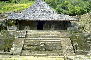
The similarities in architecture based on these pictures are the straw roof tops, the use of large leaves was common in order to keep out rain but still offer a way to keep the house cool. Today we are still able to see this technique of straw roof tops which proofs the effectiveness of such technique. The key differences is the material of the rest of the house, the Aztec seem to have used thick heavy stone, the Mayans seem to have used a perhaps clay and mud, and the Inca's used small stone.
Aztec Art
Mayan Art
Inca Art
The most prominent difference in these arts is the materials they are made of. Each indigenous group you can say became a master at working with what was available and this is clear though the detail and symbolism in their art.
Aztec God
Mayan God
Inca God
Religion beliefs for these indigenous groups played a huge role in their customs and traditions. For example offering sacrifices to the Gods such as food, animals and humans. The Aztecs built temples for their Gods, the Mayans preformed blood letting for the Gods, and the Inca's believed that their Gods would punish them if they lost faith by turning them into stone. It is interesting that these indigenous groups had stories of creation and stories of what occurs after death.
~~~~~~~~~~~~
In this map the of Latin America I have labelled important resources and significant geographical features.
I chose this map because it is showing various important factors
of South America, such as the Andes, the Amazon, the largest rain forest in the
world, and major cities. In addition many important geographical regions are
depicted.
I chose this map because it is indicating where the
conquistadors either Spanish or Portuguese began their invasion and the more
specifically the Inca region they were invading.
This map although not very clear is extremely interesting in
that it shows how the land was being divided up before the independence of the
different countries in the following century.
Contemporary Political Geography
The map is shows the nations that speak
Spanish in red and the nations that speak Portuguese in green.
I thought this was an interesting map because it indirectly shows the impact that colonization has had and continues to have on Latin America.


No comments:
Post a Comment